Offline tropical tropospheric ozone column
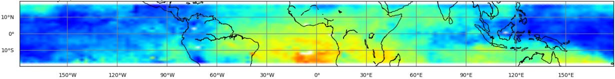
Example image
NOTE: Metop-A+B image is for demonstrational purposes only, such multi-satellite product is not processed or disseminated.
Description
The tropical tropospheric ozone column includes the tropospheric ozone from the surface up to 10 km altitude. This is far below the tropical tropopause or transition layer.
The 10 km altitude range was set for various reasons, the practical reason is that this close to the mean cloud top height of the deep convective clouds in the reference region. Because the ozone column between the cloud height and the reference height can't be directly retrieved from the measurements, a correction from calculated from a climatology is added to harmonize the different above cloud ozone columns for the different cloud top heights. To minimize the influence of the climatology the altitude was set to 10 km.
The scientific reason is that we assume most sources of tropospheric ozone and its precursors in the boundary layer, and if we include a small updraft the tropospheric ozone is close to the mean cloud altitude.
Type
Level 3. The product is available monthly with a delay of several months.
Theoretical basis
The retrieval of the product is based on GOME-2 total ozone column product and the cloud product.
Processing
DLR generates tropospheric ozone produts based on the CCD method. The tropospheric column is retrieved by subtracting the stratospheric ozone column from the total column for cloud free observations. The stratospheric ozone column is estimated as the column above high reaching convective clouds.
Units and spatial resolution
Ozone columns are given in Dobson Units (DU).
The longitudinal resolution is 2.5° and the latitudinal resolution is 1.25°. The data are limited to the range between 20°S and 20°N.
Validation
This product is validated by the KMI and IRM. The validation is based on detailed comparisons of existing satellite data with ozone soundings at several tropical stations.
Online quality monitoring
The product quality is constantly monitored by DLR.
Archiving and dissemination
This product is archived at the DLR and available via offline data access page. Upon request, products can be directly pushed to dedicated FTP servers located at the users' premises.
File format
The product is delivered in netCDF4 format, each file containing one month of tropospheric ozone data in the range of 20°S to 20°N.
Algorithm version information
| Satellite | Time period | Algorithm version | CCD algorithm version |
|---|---|---|---|
| Metop-A/B | 2015 - 11/2016 | GDP 4.7 | 1.0 |
| Metop-A/B | 12/2016 onwards | GDP 4.8 | 1.0 |
| Metop-C | 03/2020 onwards | GDP 4.9 | 1.0 |
Documents
- Product user manual
- Algorithm theoretical basis document
- Validation report (Metop-A/B)
- Validation report (Metop-C)